Winter storm warnings and advisories have been issued for parts of Alabama as snow and ice are expected to impact travel on Friday morning.
Snow is expected for the northern half of Alabama starting overnight tonight. Some areas will also see some ice.Winter storm warnings have been issued for all of north Alabama , including Huntsville, and the northern part of central Alabama , including Birmingham. They will go into effect at midnight tonight. A winter weather advisory has been issued for central Alabama roughly south of the Interstate 20 corridor. It will go into effect at midnight.
Forecasters said that temperatures will be at or just below freezing in the warning and advisory areas and will cause difficult travel conditions for the Friday morning commute, especially across north and north-central Alabama. Models were trending warmer higher in the atmosphere, which could prevent more snow from falling and increase the risk for freezing rain and sleet. Snow forecasts have decreased, but ice accumulation expectations have increased. The weather service continued to warn that adjustments to these numbers will still be possible. The snow forecast is at the top of this post. Below is the outlook for ice:Two to four inches of snow is expected across north Alabama, with the highest amounts north of the Tennessee River. Up to a tenth of an inch of ice accumulations for north Alabama, with highest amounts south of the Tennessee River. Areas north of the Interstate 20 corridor could also see significant impacts from snow and a wintry mix of sleet and freezing rain. The weather service said total snow and sleet accumulations could be between 1 and 3 inches and ice accumulations up to one tenth of an inch for those areas. The winter weather advisory areas could see total snow and sleet accumulations between 1 and 2 inches, with ice accumulations up to one tenth of an inch. Forecasters will be watching the track and speed of an area of low pressure that will move across the region, which will affect the amount of precipitation and the times it starts and stops. Also important will be how far warmer air from that low will make it into Alabama. More warm air making it farther north would cut down snow amounts and raise ice or wintry mix totals. Also important will be when temperatures rise above freezing, both during the day on Friday and on Saturday, according to the weather service. A Winter Storm Warning has been issued for northern AL and southern Middle TN from 12 AM Fri-6 AM Saturday. Periods of snow, possibly including a period of freezing rain or sleet is expected. Travel will quickly become very hazardous.Snow begins to fall late Thursday, transitions to a wintry mix during the day then changes back to snow early Saturday. This would limit the amount of snow, but potentially result in higher impacts to roads with ice accumulating.A winter storm warning will go into effect at midnight for the northern part of central Alabama, according to the National Weather Service in Birmingham. Snow and sleet accumulations of 1 to 3 inches will be possible along with potential for up to one tenth of an inch of freezing rain. The counties in the winter storm warning are: Marion, Lamar, Fayette, Winston, Walker, Blount, Etowah, Calhoun, Cherokee, Cleburne, Jefferson and St. Clair. A winter weather advisory will also go into effect for areas farther south. Accumulations of 1 to 2 inches of snow and sleet, with up to one tenth of an inch of freezing rain will be possible in those areas. Counties in the winter weather advisory are Pickens, Tuscaloosa, Bibb, Chilton, Coosa, Tallapoosa, Chambers, Elmore and Lee. The weather service said a wintry mix of snow, sleet and freezing rain will move in from the west after midnight tonight. Forecasters warned that temperatures will be at or just below freezing and will cause difficult travel conditions for the Friday morning commute, especially across the northern half of central Alabama. Precipitation could change over to rain during the day on Friday, but areas in the northern part of central Alabama could stay colder and get more winter precipitation through the day. “Small fluctuations in temperatures at the ground and above the surface, as well as the intensity of the precipitation, will play a large role in precipitation type and accumulations and associated impacts,” the weather service said Thursday morning. “The greatest concern for significant impacts will be in the newly issued Winter Storm Warning area, where heavy wintry precipitation could quickly accumulate, especially during the morning commute when temperatures will be near or below freezing.”South Alabama remained under a cold weather advisory on Thursday but had no winter precipitation warnings or advisories in effect so far. The National Weather Service in Mobile said there will be a a low chances of a sleet/rain mix at the onset of precipitation early Friday morning across interior sections of south Alabama. Precipitation could begin as sleet but then transition to all rain but sunrise. “The best chance for frozen precipitation will be across areas along and north of the U.S. 84 corridor, during a brief window before precipitation transitions to all rain after sunrise,” the weather service said in a forecast discussion on Thursday morning. “South of U.S 84, the vertical profile willremain above freezing for much of the lower levels, allowing any frozen precip to melt and fall as rain. Surface temperatures will also remain above freezing and a cold rain is If you purchase a product or register for an account through a link on our site, we may receive compensation.and agree that your clicks, interactions, and personal information may be collected, recorded, and/or stored by us and social media and other third-party partners in accordance with ou
SNOW ICE ALABAMA WINTER STORM TRAVEL WARNINGS
United States Latest News, United States Headlines
Similar News:You can also read news stories similar to this one that we have collected from other news sources.
 Mix of sun, rain, ice and snow expected as weather systems move through Central Pa.Snow flurries may hit the region on Sunday, followed by alternating days of rain and sunshine this coming week.
Read more »
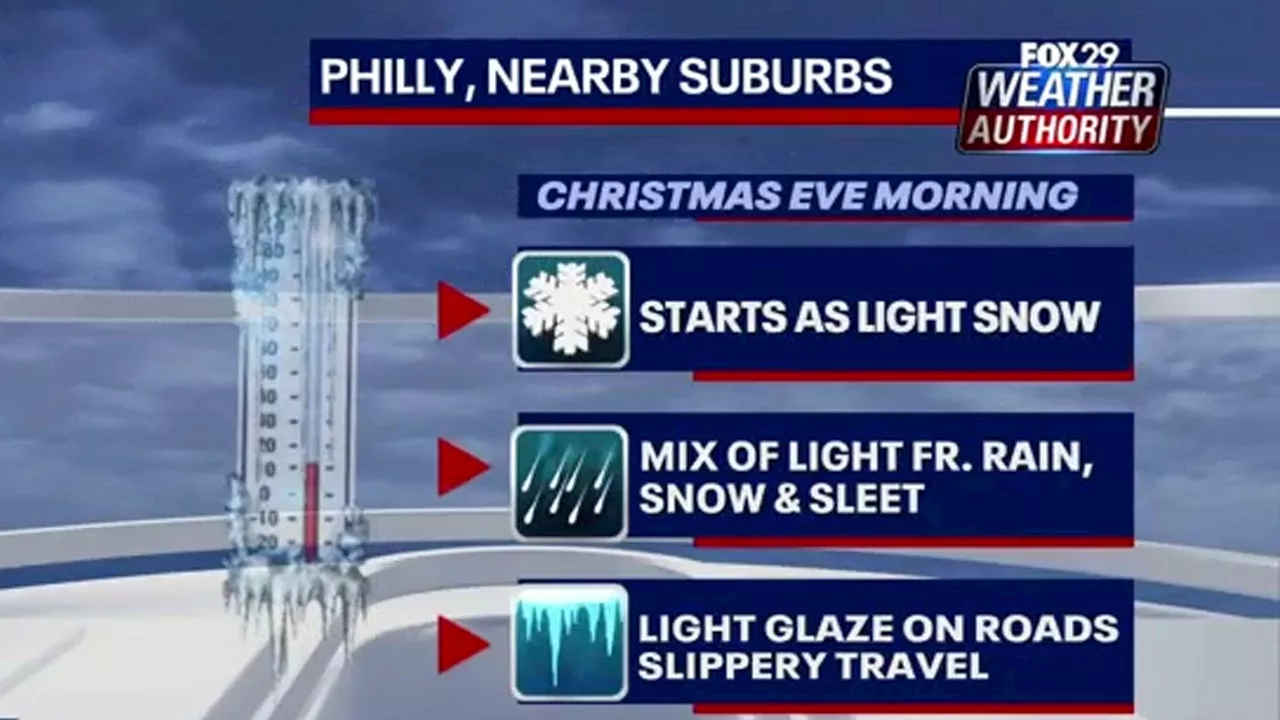 Christmas Eve Snow and Ice Expected in Philadelphia AreaA mix of snow and ice is expected to hit the Philadelphia area on Christmas Eve morning, prompting PennDOT to advise against travel. Local shoppers get a head start on their last-minute holiday errands.
Read more »
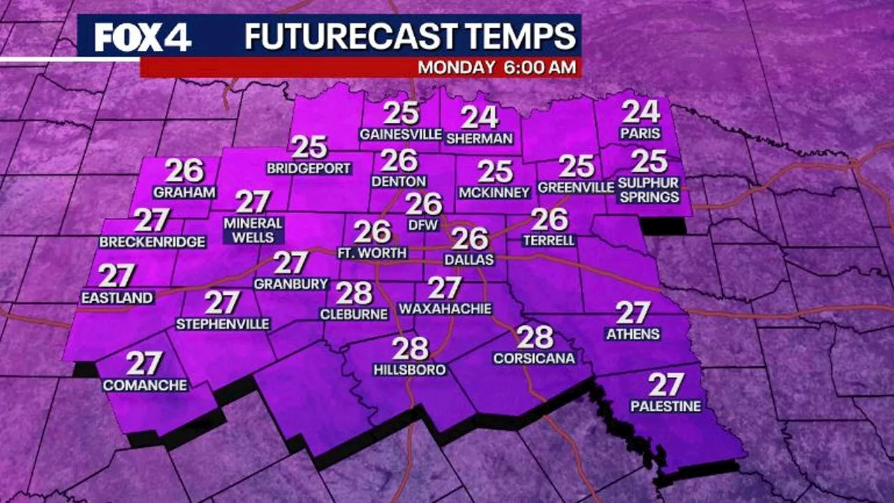 Arctic Blast Expected to Bring Freezing Temperatures and Chance of Snow/IceA cold front moving through Sunday will bring plummeting temperatures below freezing by Monday morning. While the chance of snow or ice is not certain, precipitation is possible Thursday to Friday. Road crews are already preparing for potential winter weather.
Read more »
 Heavy Snow and Ice Expected in Central OhioA winter storm warning is in effect for counties south of I-70 from Sunday morning to Monday evening due to heavy snow and ice accumulation. A winter weather advisory is in effect for counties north of I-70.
Read more »
 Heavy Mountain Snow and Blowing Snow Expected in ColoradoThe National Weather Service has issued a winter storm warning for Colorado mountains above 9,000 feet due to heavy snowfall and strong winds.
Read more »
 Ice Fishing Safety: Tips for Navigating Early Ice and Staying Safe on the IceLearn how to stay safe during early ice fishing season with tips on safe ice thickness, essential safety gear, and avoiding dangerous ice conditions. Your guide to safer winter fishing.
Read more »