
A Wind Advisory is in effect for a handful of counties in Northeast Ohio through tonight.
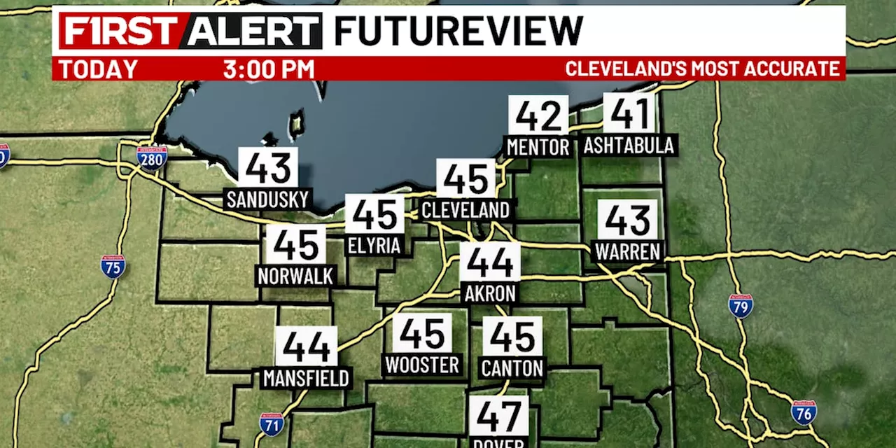
CLEVELAND, Ohio - Abundant sunshine is being seen across Northeast Ohio this Monday afternoon and will continue. High temperatures reach the mid 30s.
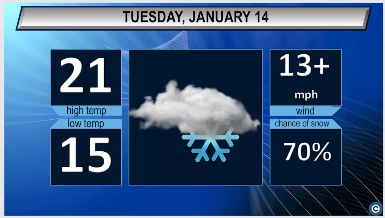
Gusty winds are expected throughout the day and will reach their peak this evening through the first part of tonight.Sporadic power flickers or outages may result.Brief bursts of snow with reduced visibility are possible and may affect travel. The highest impacts will be east of Cleveland where 1 to 3 inches of snow are expected through Tuesday morning.Most snow moves out in time for the Tuesday morning commute, but some slick roadways will be possible as temperatures drop to the 20s.Scattered snow showers are expected on Wednesday as temperatures once again climb to the 30s during the afternoon.
Much milder air is expected on Thursday and Friday as the thermometer rises to the 40s during the afternoons. Bad gas! Northeast Ohio gas station customers out thousands in repairs, and the problem just got worseCoroner: 19-year-old killed in I-71 crashNortheast Ohio weather: High winds Monday; snow returns Monday night
United States Latest News, United States Headlines
Similar News:You can also read news stories similar to this one that we have collected from other news sources.
 Northeast Ohio Weather Forecast: Warming Temperatures and Windy ConditionsNortheast Ohio residents can expect a mix of milder temperatures and strong winds over the coming days. While temperatures will start in the teens, they will climb into the low 30s by afternoon. Snow chances are low, with the best opportunity for light snowfall south of Cleveland later this afternoon. Strong winds are expected, particularly on Monday, with gusts reaching over 40 mph.
Read more »
 Arctic Blast to Hit Northeast Ohio with Snow and WindNortheast Ohio braces for continued frigid temperatures, reaching only the low 20s Tuesday with wind gusts up to 28 mph, causing wind chill values as low as -1 degree. Snowfall is also expected, ranging from 1-2 inches near Cleveland to 4-6 inches in the primary snowbelt and up to 8 inches east of Cuyahoga County.
Read more »
 Wind gusts could top 50 mph tonight in NE Ohio; thousands without powerThe National Weather Service has issued a wind advisory most of Northeast Ohio.
Read more »
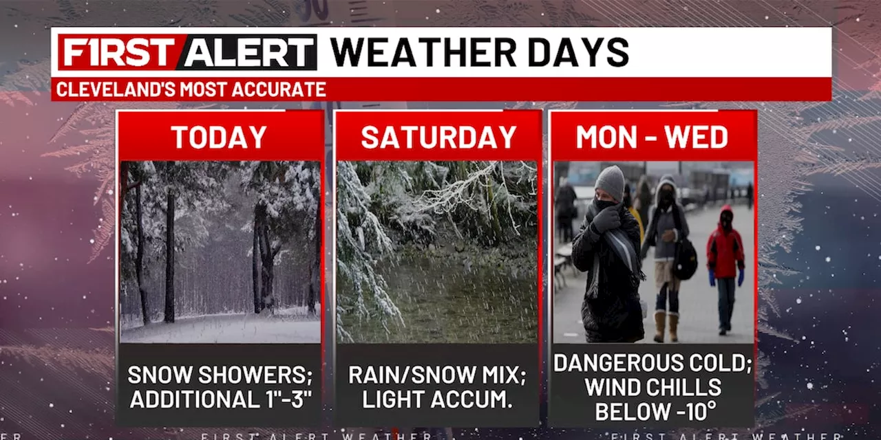 Northeast Ohio Weather: A Break from the Bitter Cold Today; Snow Returns TomorrowThe snow starts to decrease overnight with temperatures dropping to the mid-20s. Friday is expected to be dry with some sunshine and temperatures rising above freezing. Rain is possible on Saturday, changing to snow as temperatures drop. Scattered snow showers are anticipated on Sunday with low temperatures. Dangerous cold returns Monday morning with lows near zero and wind chills near -10 degrees. Tuesday and Wednesday mornings will also see temperatures below zero and wind chills below -10 degrees.
Read more »
 Northeast Ohio Weather Forecast: Rainy New Year's Eve Transitioning to SnowA departing weather system brings sunshine and mild temperatures for the remainder of the day. However, rain is expected on New Year's Eve, transitioning to snow overnight as temperatures drop. The new year begins with lingering snow showers and a prolonged cold spell.
Read more »
 Winter Storm Watch Issued for Northeast OhioA winter storm watch has been issued for Cuyahoga and Ashtabula counties, along with other northern counties, from Wednesday through Sunday. Accumulations of at least six inches of snow are predicted, with the heaviest snowfall expected in Ashtabula, Cuyahoga, Geauga, and Lake counties. Light to moderate snow is expected on Wednesday, with lake effect snow possible through Saturday night.
Read more »