
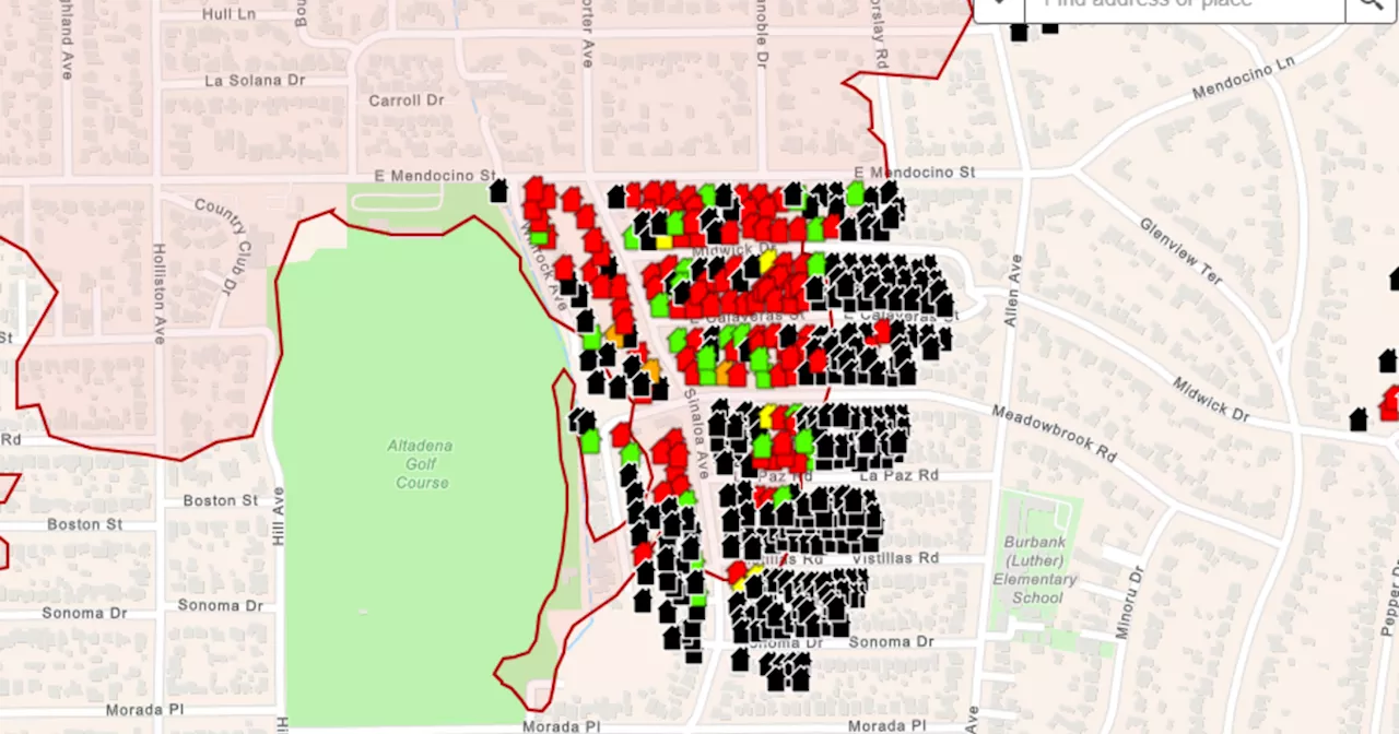
Los Angeles County has released preliminary maps showing the damage caused by the Eaton and Palisades fires, providing some insight for evacuated residents. While repopulation efforts are underway, safety remains the top priority, with over 92,000 people still under evacuation orders. Crews continue to work tirelessly to assess damage and locate missing persons.
Access to numerous neighborhoods within the Eaton and Palisades fire zones remains restricted. Los Angeles County has released preliminary maps depicting the extent of damage to structures and homes. As of Monday, over 92,000 people are still under evacuation orders, according to Los Angeles County Sheriff Robert Luna.These maps, though not yet complete, offer evacuated residents a glimpse into the condition of their properties.
They can determine whether their home is intact or ascertain the level of damage sustained. However, many residents are still prohibited from returning to their neighborhoods. 'Repopulation will not occur until all areas are deemed safe,' stated Los Angeles County Fire Department Chief Anthony Marrone.The maps utilize a color-coding system to categorize structure damage assessments, ranging from complete destruction to major and minor damage, those affected, and those with no damage. Marrone emphasized that the maps are undergoing daily updates, adding that 'if there is not a color icon on your address, it means the building has not yet been inspected.' Luna echoed Marrone's sentiments, stressing that repopulation is a top priority. 'We are attentively listening to our community and we want to enable your return as expeditiously as possible,' he said. He acknowledged the presence of ongoing hazards in the area and the tireless efforts of crews to locate those who have perished.'Regarding the Altadena area, we are currently on the third day of grid searching,' Luna explained. 'It is a deeply somber task... We understand the sentiment, 'I just want to go look at my house and see what's left.' We share that sentiment, but our teams are engaged in the arduous task of locating the remains of your neighbors. We kindly request your patience.'
Eaton Fire Palisades Fire Los Angeles County Evacuations Fire Damage Repopulation Safety Missing Persons
United States Latest News, United States Headlines
Similar News:You can also read news stories similar to this one that we have collected from other news sources.
 Los Angeles County Releases Preliminary Damage Maps for Eaton and Palisades FiresAccess remains restricted in affected areas as over 92,000 people remain under evacuation orders. Preliminary maps show damage assessments ranging from destruction to minor damage.
Read more »
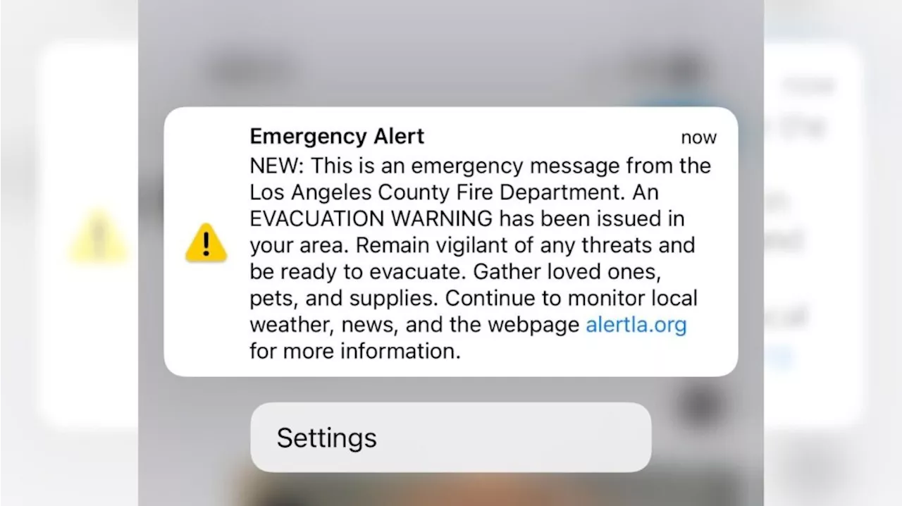 LA County Fire mistakenly sends out emergency evacuation alert to entire countyThe alert caused many residents, already tense, to fear their homes were now in danger, too.
Read more »
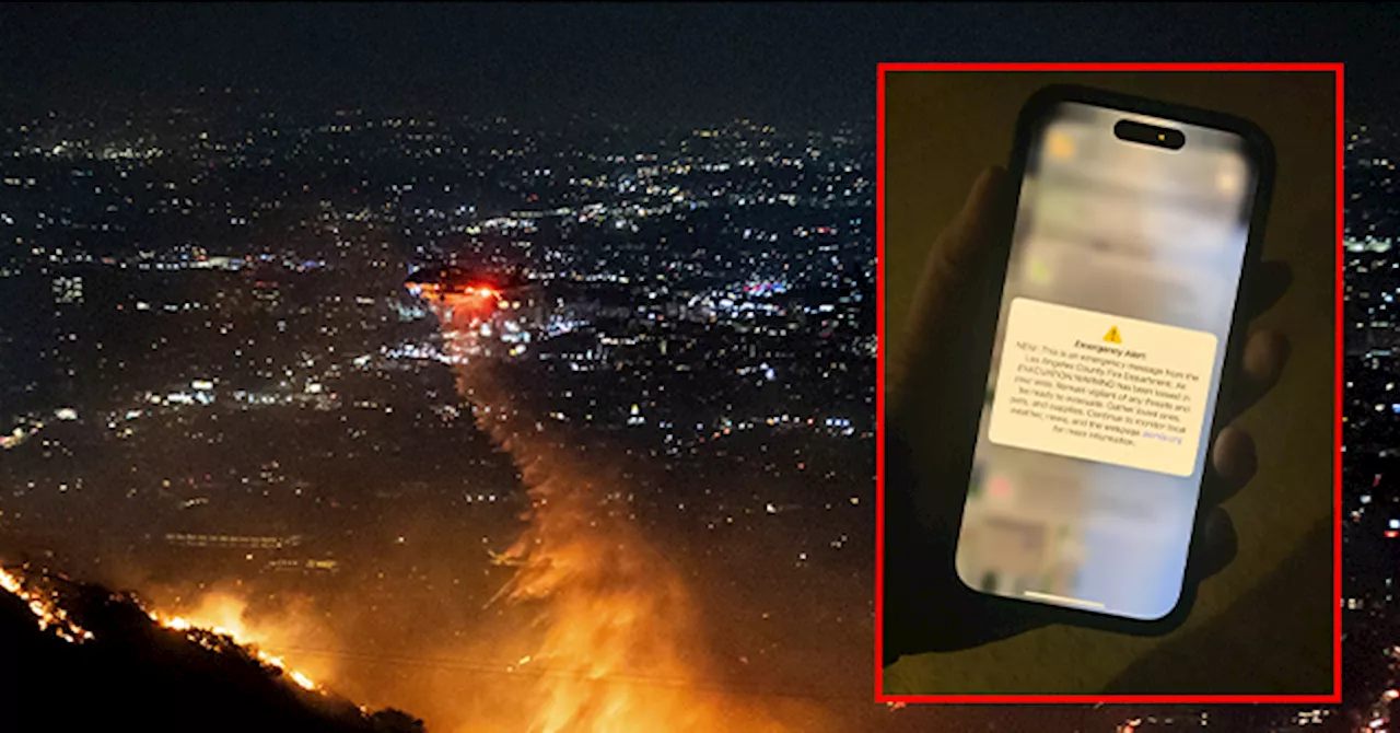 Los Angeles County Fire Department Accidentally Sends Evacuation Alert to All of L.A. CountySource of breaking news and analysis, insightful commentary and original reporting, curated and written specifically for the new generation of independent and conservative thinkers.
Read more »
 LA County Fire mistakenly sends out emergency evacuation alert to entire countyAnother alert was issued shortly after announcing that it was only for areas near West Hills.
Read more »
 Map: See where Los Angeles County wildfires are burningThe Palisades Fire, Eaton Fire, Hurst Fire, Lidia Fire and Sunset Fire are burning Friday in Los Angeles County. See updates and locations.
Read more »
 Cal Fire's Fire Hazard Severity Zone Map Shows California Fire RiskCal Fire's new Fire Hazard Severity Zone map allows Californians to search for an address and see the location's probability of being affected by fire. The map assesses fire hazard, rather than risk, based on the physical conditions that create a likelihood of fire behavior over a 30 to 50-year period. The map considers terrain, local weather, and fire history over 50 years. Areas are ranked as moderate, high, or very high fire severity. The map is effective as of April 1, 2024 and focuses on areas under state responsibility, excluding federal land like the Sierra Nevada Mountains and some parts of the Bay Area.
Read more »