It felt anticlimactic, at first.
The P3 Orion bumped and jiggled a bit, and all Kerry Emanuel could see of hurricane Gloria was grey and rain streaming down his passenger window.
It was 1985 and the then young hurricane researcher had buckled into an airforce plane taking off from Puerto Rico to fly into what the papers back on the Eastern seaboard were calling the Storm of the Century.
Hundreds of thousands were being evacuated in North Carolina as the Orion entered the eye at the heart of Gloria’s churning gyre.
“It’s like being in a stadium 12 miles high and a hundred miles across,” said Emanuel of entering the storm’s eye.
“With great big white gleaming walls that slope outward like in a colosseum. There’s this very deep blue sky overhead and a very agitated ocean surface below you. It’s magnificent.”
If the laws of physics would have allowed that converted sub-hunter to hold its rivets still and for Emanuel to open his window, he could have felt a tower of calm powerful enough to inspire tired metaphors beyond count.
But the plane quickly plunged into the opposite wall of cloud.
Gloria would ultimately kill 14 people after making landfall in North Carolina, shut down New York City for a few hours and cause US$900 million in damage.
Though it's hard to imagine newspapers exaggerating, the papers were wrong; it wasn’t the storm of the century.
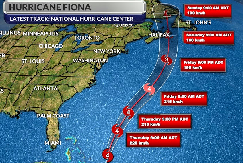
This most recent run of the HWRF model brings #Fiona to landfall with a central pressure of 914 mb, which is just unthinkable. For perspective, at lower latitudes that would be a Category 5 hurricane. This will be a storm for the Canadian history books. https://t.co/cd85Eypmng pic.twitter.com/nB9CwduziM
— Brian McNoldy (@BMcNoldy) September 22, 2022
Emanuel can see how the excitement was understandable at the time. Gloria was the first system of tropical storm strength or greater to make landfall in the United States in 13 years and the first hurricane to hit New York State in 25 years.
Which might seem odd to us now. Eleven hurricanes have made landfall (usually as post-tropical storms) in Atlantic Canada over the past 12 years. In the 25 years preceding Gloria’s 1985 arrival as a post-tropical storm with 93-kilometre-per-hour wind gusts in the Bay of Fundy, Atlantic Canada got hit by six such storms.
There are more hurricanes and they’re getting stronger. We can thank, counter-intuitively, the Clean Air Act.
“During the 1940s-’70s, we put a heck of a lot of sulphur into the atmosphere,” said Emanuel.
“That undergoes a chemical reaction and becomes a haze particle. It got thicker and thicker through the ’70s and now we know it was reflecting sunlight back into space an cooling tropical oceans, which led indirectly to this big drought in hurricanes during the 70s and 80s. Then we passed the Clean Air Act, which worked, it cleaned up the atmosphere and the hurricanes came roaring back.”
It’s not actually that we’re getting more hurricanes, it’s that by pumping smog into the atmosphere we had fewer for about two decades.
Don’t get Emanuel wrong, he’s all for clean air. During a career that saw him become one of the world’s leading hurricane researchers, he did the math to show how a warming climate will allow hurricanes to get bigger and more powerful.
We’ll use Fiona, which, as it barrels toward us is getting labeled with descriptors similar to that of hurricane Gloria, to show how.

Birth of a hurricane
There are a couple of ways a hurricane can start.
But it appears Fiona started, like most of them, not as a hurricane at all.
Weeks or months ago, the sun was shining hard on the Sahara, as always. The hot sand heated the air above it, which rose and rubbed against the cooler, denser air over moister areas just to the south. The friction of the world spinning underneath caused these rubbing air masses to start spinning.
That mass of air would have been harmless enough as it moved out of Africa and west across the Atlantic, had it not come across warm, moist air rising over tropical water. Then it began building into a hurricane, or as Emanuel calls them, a “heat engine” that transfers the heat energy in the water into the momentum of the spinning winds.
It works like this: the warm humid air above the ocean rises, and as that moisture gets high it cools and condenses, forming the clouds and rain of the hurricane. When a substance changes states from a gas to liquid (condensation) it releases a large amount of energy that goes into the wind.
Just like gasoline is for your car and a poutine is for your body, the warm rising air is the fuel of this engine. With climate change making the Atlantic warmer, Fiona found all kinds of fuel.
“As you put greenhouse gases into the atmosphere, it serves to trap more heat in the ocean and raises the amount of fuel,” said Emanuel.
“It just means that once you have a hurricane it can get more intense. In recent years, colleagues of mine in different places have started to see this in the actual data of hurricanes.”
The data says that as the oceans continue to warm, we’ll get bigger hurricanes.
'Very damaging winds'
And Fiona is a big storm by the standards of what we see make landfall in Nova Scotia.
“Into Saturday morning we expect extreme winds to the right-hand side of the track and also very damaging winds to the left of the track,” Bob Robichaud, warning preparedness meteorologist at the Department of Environment and Climate Change said during a briefing Thursday.
“We could see easily 100 to 150 millimetres of rain but we can’t rule out 200 millimetres of rain. This is the total rainfall amount by Sunday morning. Expect coastal flooding along the Eastern Shore into the Northumberland Strait, P.E.I. and eastern New Brunswick.”
Though there is a wide cone of uncertainty, the models appear to have the storm making landfall near Canso and then continuing up through Cape Breton. Those models are expected to shift as the storm gets closer.
Along the Northumberland Strait and around the bottom of St. George’s Bay the storm surge will be peaking early Saturday morning at high tide, potentially compounding flooding caused by the huge rainfall.
Fiona has aleady left a trail of destruction and death in places like Puerto Rico, where at least eight people are dead and most of the island's population is without power.